|
General Circulation
>> Global pattern of winds caused by
uneven heating of the Earth's surface
>> Everything is connected
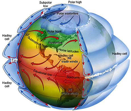
As mentioned before, the global
pattern of winds is caused by the uneven heating of the Earth's surface.
These winds work to move cooler air toward the Equator and warmer air toward the
poles. All of the global wind patterns are connected to one another in
some way.
Tropics Review
>> Hadley Cell
A convection cell that is located from
the Equator to approximately 30 degrees latitude in both hemispheres
>> Trade Winds
The winds of the Hadley Cell that are
at the surface and that blow toward the Equator are called the Trade Winds.
>> Intertropical Convergence Zone
An area where the Trade Winds converge
and rise. The rising air in this area gives way to a band of unsettled
weather in each hemisphere.
>> Monsoon
The seasonal reversal of wind
direction.
>> Subtropical Jet Stream
A stream of fast moving winds found
above the subtropical high pressure systems at approximately 30 degrees
latitude. The strength of this jet stream is dependant on the strength of
the temperature and pressure gradients that occur when the air from the tropics
meets the air from the mid-latitudes.
Mid-latitudes: 30 to 60 Degrees Latitude
>> Polar Front: Boundary between warm,
tropical air and cold, polar air
The polar front is a boundary between
the warm, tropical air and the cold, polar air. This front is strongest
and farthest south during the cold winter months. The polar front is
labeled below in Figure 1.
|
 |
|
Figure 1:
The image above shows the position of the polar front as the boundary
between warm, tropical air and cold, polar air. |
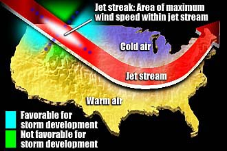
>> Mid-latitude Jet Stream: A narrow
channel of fast-moving, high-level winds that runs through the Westerlies
|
 |
|
Figure 2:
The jet stream separates warm air from the tropics from cold air from the
poles. It also has an impact on storm movement and development. |
The mid-latitude jet stream is a
narrow channel of fast-moving winds that runs through the Westerlies. This
jet stream, like the subtropical jet stream, is a result of the large
temperature contrast that occurs over a short horizontal distance. The jet
stream doesn't just move west to east, it also can form dips and bulges that are
called troughs and ridges respectively.
The mid-latitude jet stream plays a
huge part in how the various weather systems move throughout this area of the
world. Not only does this stream of air steer the various weather systems,
but it also can help to energize various atmospheric features. For
example, cyclogenesis (formation of a low pressure system) usually occurs on the
east side of an upper-level trough. Anti-cyclogenesis (formation of a high
pressure system), however, occurs on the east side of an upper-level ridge.
This is mainly due to the positioning of upper-level convergence and divergence,
which work to increase or decrease the surface pressure respectively.
Figure 2, found to the right, illustrates the basic properties of the
mid-latitude jet stream.
High Latitudes: Above 60 Degrees Latitude
>> Relatively high surface pressure
The surface pressure in the high
latitudes is relatively high due to the cold, dense air that is present
throughout this region. In this region, the three cell model is completed
as upper-level convergence occurs above the poles. This causes the air
above each pole to sink toward the surface. Once at the surface the cold
air flows toward the Equator. The Polar High and the Polar Easterlies can
be seen in Figure 1 above.
As discussed earlier in the semester,
sinking air causes the atmosphere to be very stable. It is for this reason
that pollutants from across the globe tend to linger at the poles.
Air Masses
>> Large chunks of air several
thousand miles wide and a few miles deep with relatively uniform temperature and
moisture characteristics
>> All of the air masses have an abbreviation that gives insight into its
properties
Each air mass has its own two letter
abbreviation that gives insight into its properties. The first letter of
the abbreviation (lowercase "m" or "c") outlines weather the air mass is a dry,
continental air mass or a moist, maritime air mass. The second letter in
the abbreviation (capital "P", "T" or "A") gives an indication of the
temperature of the air mass. The various abbreviations can be seen below.
The origins of these air masses can also be seen in Figure 3.
|
Abbreviation |
Official Name |
Atmospheric Property |
|
m |
Maritime |
Moist |
|
c |
Continental |
Dry |
|
P |
Polar |
Cold |
|
T |
Tropical |
Warm |
|
A |
Arctic |
Damn Cold |
|
Table 1:
The table above outlines the abbreviations used to identify various air
mass. |
|
|
|
Figure 3:
The map above illustrates the origin of each type of air mass that impacts
the United States. |
Fronts
>> The boundary between two different
air masses
>> Relatively large temperature and/or moisture gradients
>> Relatively low surface pressure
|
 |
|
Figure 4:
The image above illustrates the basic structure of a front.
Notice the converging surface winds and rising air along the front. |
Surface winds converge at the front
and, therefore, the air rises, condenses and cools to form clouds and
precipitation. In addition to the formation of the clouds and
precipitation, the rising air leads to a drop in surface pressure in areas
around a front. The basic structure of a frontal boundary can be seen to
the left in Figure 4.
|