|
General Circulation
>> Global pattern of winds caused by
the uneven heating of Earth's surface
>> Redistributes warm and cold air
The general circulation works to
redistribute the warm and cold air over the entire globe. The wind
patterns associated with the general circulation work to cool the tropics and warm
the poles. A map outlining the general global pattern of winds can be seen
in Figure 1 below.
|
 |
|
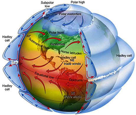
Figure 1:
A three-dimentional view of the general circulation |
>> Everything is connected to some
degree (teleconnections)
Hadley Cell
>> A convection cell that is located
from the Equator to approximately 30 degrees latitude in both hemispheres
The Hadley Cell is a convection cell
that is located in the tropical regions of both hemispheres. In this cell
air rises above the Intertropical Convergence Zone (ITCZ) and flows northward in
the northern hemisphere (southward in the southern hemisphere) to about 30
degrees latitude. At approximately this latitude the air sinks toward the
surface and then returns equatorward. The winds at the surface that blow
toward the equator are called the trade winds. The trade winds are labeled
on the map in Figure 1.
Several distinct atmospheric features make up the Hadley Cell. The region
in which the air rises and then diverges aloft develops a belt of low pressure (the ITCZ) which is
labeled as the equatorial low in Figure 1. At around 30
degrees latitude convergence of air aloft leads to sinking air and to the development of subtropical high pressure systems.
Also, this region of the globe is home to the subtropical jet stream. This
stream of fast moving air found above the surface is the result of the
deflection of upper-level winds by the Coriolis effect. Essentially,
eastward momentum is transferred from the fast-rotating tropics to the slower-rotating
higher latitudes.
The Hadley Cell circulation can be seen above in Figure 1.
>> Monsoon: The seasonal reversal of
wind direction
El Niño
>> An abnormal warming of the topmost
layers of water in the Eastern Pacific Ocean
>> Occurs in irregular intervals of 2 to 7 years
>> Weakening of the Trade Winds
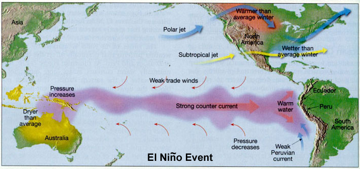
An El Niño occurs in irregular
intervals of two to seven years when the trade winds weaken significantly.
This oceanic and atmospheric event results in the warm water of the Western Pacific Ocean
moving eastward. The weakening trade winds cause the upwelling of nutrient-rich waters
along the Peruvian coast to cease. This, in
turn, causes the food chain in the Peruvian waters to be disrupted.
Occurrences of El Niño have a drastic impact on the economy along the Peruvian
coast.
>> Global weather patterns are altered
The limited data concerning
the impacts of El Niño suggest the following teleconnections.
Throughout the United States, El Niño seems to bring somewhat stormier
conditions to southern California, wetter conditions to the Gulf Coast states
throughout the winter months, and warmer and drier conditions to the northern
tier states during the winter. Also, El Niños seem to make the
Atlantic hurricane season less active and work to cause abnormally dry
conditions in Southeastern Asia (Western Pacific). A comparison of normal
conditions and those found during an El Niño can be seen in Figures 2
and 3 below.
|
 |
|
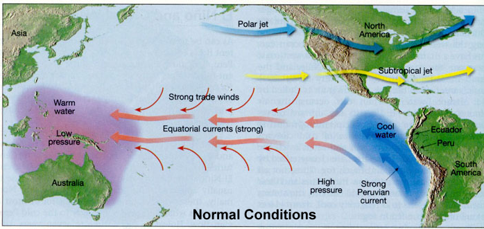
Figure 2:
The picture above outlines typical conditions throughout the Western Pacific
Ocean. Notice that the strong trade winds keep the warm water from
advancing eastward toward South America. |
|
|
|
Figure 3:
In comparison to Figure 2, this picture illustrates the typical conditions
found during an
El Niño
event. Notice that the trade winds have weakened, allowing the warm
water to advance eastward to the South American coastline. Equatorial upwelling
from Eckman transport is also reduced. |
|