|
Flash Flooding
>> The number one direct weather-related
killer in the United States
|
 |
|
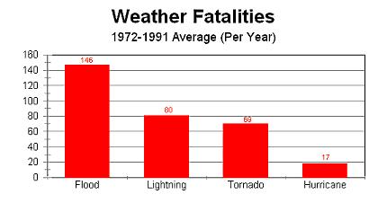
Figure 1:
The graph above shows that floods have caused the most weather-related
deaths in the United States from 1972-1991. |
Flash flooding is the number one
weather-related killer in the United States. These floods, which generally
occur within six hours of the onset of precipitation, killed over 10,000 people
in the United States since 1900. Figure 1, found to the right,
compares the deaths due to flooding with other fatal weather events.
>> Occurs when more rain falls than the ground can absorb and when it falls
heavily enough to cause sudden, rapid runoff
>> Atmospheric factors
There are three primary ways flash flooding episodes develop. One important factor
is the strength of the upper-level winds. Very weak upper-level steering
winds can work to cause slow-moving and/or stationary thunderstorms. This
will cause the thunderstorms to dump a large amount of rain over one specific
area for an extended period of time.
Flash flooding can also be caused by
multiple thunderstorms continuously forming and moving over the same spot.
This atmospheric process is called training.
Finally, flash flooding can be caused by
orographic lifting, when a moist and unstable airmass ascends the side of a mountain and the prevailing
winds continue to blow additional moist, unstable air to the same location.
Microbursts
>> Exceptionally strong thunderstorm
downdraft caused by unusually strong evaporational cooling
|
 |
|
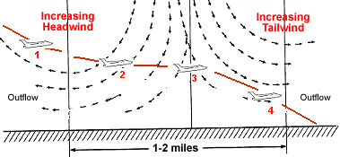
Figure 2:
The image above shows the difficulty airplanes face when encountering a
microburst while landing. |
A microburst is an exceptionally
strong thunderstorm downdraft that is caused by unusually strong evaporational
cooling within the storm. These microbursts can cause strong straight-line
winds that are often in excess of 100 miles per hour. They are also a
major threat to landing aircraft as they cause a large difference in wind
direction over a very small distance. The impact of microbursts on
airplanes can be seen in Figure 2 to the left.
Hail
>> Pieces of ice formed in the
thunderstorm's updraft
>> Also known as the "white plague"
>> Ingredients needed for hail formation
|
 |
|
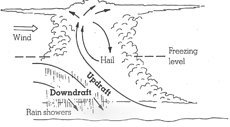
Figure 3:
The image above illustrates the process of hail formation in a thunderstorm.
|
A few key ingredients are needed to
produce hail. The first: freezing air needs to be
located relatively close to the ground, but not TOO close.
The second and most important
ingredient for large hail formation is a strong updraft. The updraft needs
to be strong enough to support the ever-growing hailstones. Once the
updraft can't support the hailstones any longer, they fall out of the
thunderstorm toward the ground. The process of hail formation can be seen
in Figure 3 to the right.
Organized Thunderstorm Complexes
>> Squall Line: A band of
thunderstorms that often forms well ahead of a cold front
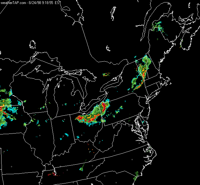
A squall line is a band of
thunderstorms that often forms well ahead of a cold front. In order to
produce a squall line a rich supply of warm, moist air is needed. This
requirement is often met if there is a low-level jet stream present in the area.
This low-level jet will work to bring warm, moist air in from the south.
In addition to the presence of warm,
moist air, these squall lines often form in association with large upper-level
divergence and large scale lifting. This is why squall lines are most
often found ahead of a frontal system. A squall line can be seen moving
through Pennsylvania in the radar loop below.
|
 |
|
Figure 4:
The radar loop above shows a squall line moving through Ohio and
Pennsylvania on August 24, 1998. |
>> Mesoscale Convective Complex (MCC):
Primarily nocturnal bundle of thunderstorms that stretch across hundreds of
miles
|

|
|
Figure 5:
The satellite image above shows a mesoscale convective complex over
Oklahoma. |
The mesoscale convective complex is a
nocturnal bundle of thunderstorms that stretch across hundreds of miles.
Much like a squall line, the low-level jet stream feeds warm, moist air into
these thunderstorm complexes. In this case, however, a mid-level low
pressure forms within the group of storms. This low pressure helps to
sustain this large group of thunderstorms. Mesoscale convective complexes
are very common in the Plains states and help to provide a good majority of the
rain throughout that area. An infrared satellite image of a MCC can be
seen to the left.
|