|
Winter Precipitation Types
>> Snow
Snow occurs when the entire column of
air is below freezing or if there is only a thin layer of air that is above
freezing. If this thin layer of warmer air is near the surface, it results
in wet snow. If the layer is not near the surface, however, it results in
distorted snowflakes due to the partial melting and refreezing process.
>> Sleet
Sleet occurs when there is a thick
layer of above-freezing air (melts falling snow) overlying a thick layer of
below-freezing air (freezes drops of water into little balls of ice).
Often when it is sleeting the surface temperature is below freezing, unlike
what it would be for hail. In fact, the vertical temperature profile
for sleet is much different than that for hail.
>> Freezing Rain
Freezing rain occurs when there is a
thick layer of above-freezing air (melts falling snow) overlying a THIN layer of
below-freezing air AT and just above the surface. This means the
raindrops do not refreeze until they come in contact with an object at the
surface that is below freezing. Freezing rain results in a
smooth sheet of ice on untreated roads and the heavy loading of ice on trees and
powerlines.
These three situations, along with that for rain can be observed
in an interactive demonstration found below in Figure 1.
|
|
|
Figure 1:
The demonstration above outlines the differences between each type of winter
precipitation. In order to view the temperature profile of each case,
move your mouse over each type of precipitation. |
Lake Effect Snow
>> Occurs anywhere on the planet where
sub-freezing air flows over relatively warm bodies of water
>> "Fair weather" event
Lake effect snow usually occurs when
there is an approaching high pressure system with large-scale subsidence, so areas not
influenced by the lake (upwind of it) will see improving weather.
>> Intensity of snowfall
The intensity of lake effect snowfall
depends on five key factors. The first is the stability of the lower atmosphere. Formation of lake
effect snow requires the lake temperature to be warmer than the air temperature.
The larger the difference in these two temperatures, the greater the instability and
the faster the air will rise. As a general rule of thumb, deeper
bodies of water will stay warmer for a longer time and will, therefore, produce
more intense lake effect snows for a longer period of time. The typical
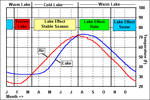
lake effect snow season can be seen below in Figure 2. Note that the deeper
lakes do not freeze, thus extending the lake effect snow season.
|
 |
|
Figure 2:
The figure above shows the typical lake effect snow season for the Great
Lakes. Notice that lake effect snow only occurs when the lake
temperature is greater than the air temperature. |
|
 |
|
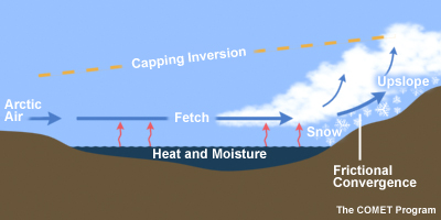
Figure 3:
The image above illustrates the various ingredients that impact the
intensity of lake effect snow. |
The second key factor in determining
the intensity of lake effect snow is the height of the subsidence
inversion. This determines how deep the clouds can
get. If the subsidence inversion is relatively high, the clouds can become
much deeper and will produce more snow.
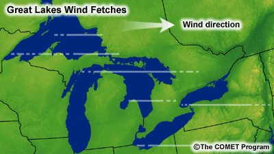
The third important factor is the
fetch, or the distance over which the air will travel over the warmer lake
waters. The fetch is important in that a longer fetch will provide more
"fuel", or water vapor, for the development of heavier lake effect snow. For
example, a north wind will produce a narrow band of very heavy snow to the south of Lake
Michigan, while a (cold) west wind will produce multiple weaker bands to the east.
The wind direction versus height, or
wind shear, is also very important in determining snow intensity. In order to produce
more intense snowfall, there should be little to no change in the wind direction
with height. Limited wind shear allows the clouds to organize such that they grow
deeper and produce more snow.
The final factor in determining the
intensity of lake effect snow is topography. The simple fact that the
air over water will encounter less friction than that moving over land means that there
will be convergence at the shore, where the fast-moving air converges with the slower-
moving air. This is known as frictional convergence, and it causes enhanced snowfall just
inland from the lakeshore. In order to produce the most intense snows possible,
orographic lifting will combine with frictional convergence when the terrain slopes upward
away from the lakeshore. Increased orographic lifting allows for more upward motion, which, in
turn, forces the air to rise and cool more, which results in enhanced snow. The Tug Hill Plateau lies
to the east of Lake Ontario and even though the elevation change is not drastic, average annual snowfall
in that region exceeds 200 inches, while areas closer to shore at lower elevation average half as much.
A nice summary of the factors determining lake effect snowfall intensity can be seen in Figure 3.
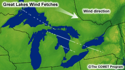
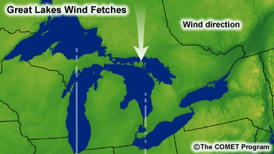
>> Location of snow
Wind speed and direction obviously determine
where the snow will fall. The direction of the wind determines the general snowfall areas, where as the speed
determines how far the snow bands will spread inland from the shoreline. The impact of wind direction on the location of lake
effect snow can be seen in the four images below.
|
 |
 |
|
 |
 |
|
Figure 4:
The four images above show the impact of wind direction on the placement of
lake effect snow bands. Notice that each wind direction produces snow
bands that are positioned over drastically different parts of the Great
Lakes region. |
Wind Chill
>> Additional cooling to exposed skin
caused by the wind
Wind blowing over the skin causes
increased evaporation of sweat from the skin, further cooling it. It also
works to strip away the thin layer of warm air just above the skin surface.
The combination of these two factors is what is realized as the wind chill.
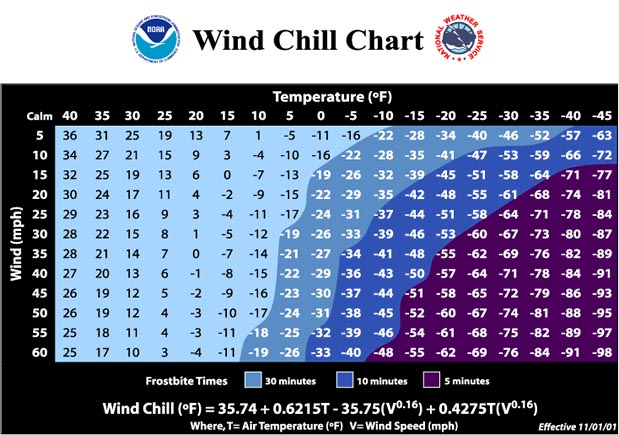
A wind chill chart can be found below in Figure 5.
|
 |
|
Figure 5:
The chart above shows the wind chill factor for various temperatures and
wind speeds. Also, notice that each wind chill value has a frostbite
time associated with it. |
|