|
Stability Terminology
>> Hydrostatic Equilibrium: Vertical
PGF and Gravity in balance
>> Lapse Rate: Rate of decrease of temperature with elevation
|
 |
|
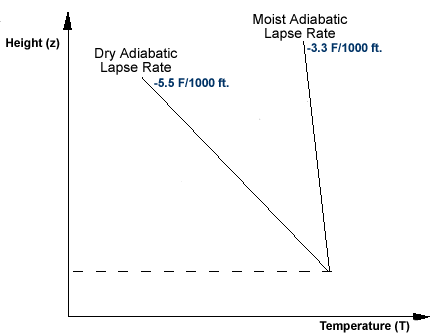
Figure 1:
The image above shows the dry and moist adiabatic lapse rates and their
relative (not to scale) orientation with respect to height. |
In the atmosphere, rising or sinking air will only cool
or warm at one of two rates - the dry adiabatic lapse rate or the moist
adiabatic lapse rate. The first, the dry adiabatic lapse rate, is the rate
an unsaturated parcel of air warms or cools when moving vertically through the
atmosphere. The dry adiabatic lapse rate is approximately a 5.5 degree
Fahrenheit change in temperature for every 1000 feet of vertical movement.
The moist adiabatic lapse rate, on the
other hand, is the rate at which a saturated parcel of air warms or cools when
it moves vertically. This lapse rate is approximately 3.3 degrees Fahrenheit
for every 1000 feet of vertical movement.
Rising air cools, sinking air warms- no exceptions!
The actual stability of an air parcel
is determined by the orientation of the environmental lapse rate in comparison
with either the dry or moist adiabatic lapse rates. The environmental
lapse rate is simply what it says- the rate of change of the temperature of the
environment (atmosphere) with changing altitude. It is important to
relaize that because the atmosphere (environment), on average, is not rising or
sinking, the environmental lapse rate can look much different than the dry or moist
adiabatic lapse rates. In fact, it is those differences that allow us to
determine whether a particular part of the atmosphere is stable or
unstable. The dry and moist adiabatic lapse rates can be seen in
Figure 1 to the right.
>> Unstable Equilibrium or "Unstable":
Parcel accelerates away from initial position
|
 |
|
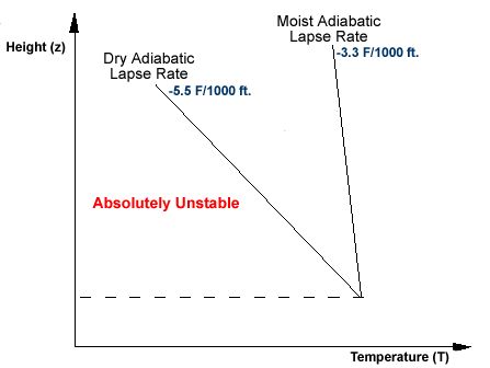
Figure 2:
This image
illustrates the concept of unstable equilibrium. In this case, the
environmental lapse rate is greater than both the dry and moist adiabatic
lapse rates. |
The atmosphere is considered to be
unstable if a rising parcel cools more slowly than the environmental lapse rate.
This causes the air parcel to remain warmer and less dense than its surroundings
and, therefore, continue to accelerate upward. The orientation of an
unstable environmental lapse rate can be seen to the left in Figure 2.
>> Stable Equilibrium or "Stable":
Parcel resists vertical motion
|
|
|
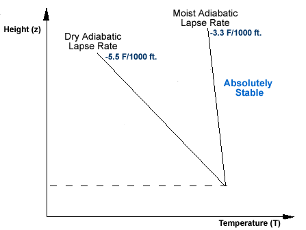
Figure 3:
This image illustrates the concept of stable equilibrium. In this
case, the environmental lapse rate is less than both the dry and moist
adiabatic lapse rates. |
The atmosphere is considered to be
stable if a rising parcel cools faster than the environmental lapse rate.
This causes the air parcel to be cooler and more dense than its surroundings
and, therefore, lose its buoyancy. Vertical motions tend to be restricted
when the atmosphere is in stable equilibrium. The orientation of a
stable environmental lapse rate can be seen to the right in Figure 3.
>> Temperature Inversions
|
 |
|
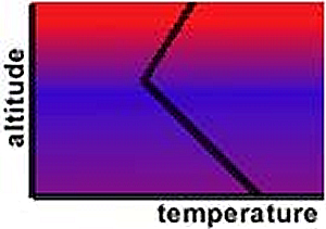
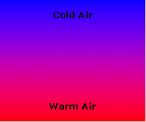
Figure 4:
The figure above shows a typical temperature inversion. An inversion
occurs when temperature increases with height, a situation "inverted" from the general
temperature decrease with altitude in the troposphere. |
A temperature inversion occurs when
the temperature increases with height. The environmental profile
associated with a temperature inversion is the most stable type of environment.
A temperature profile featuring an inversion can be found to the left in
Figure 4. The inversion is at the top, where temperature increases
with height.
Stability and Vertical Mixing
>> Unstable Environment: Promotes
mixing through the rising and sinking of bubbles of air
|
|
|
Figure 5:
This figure illustrates the vertical mixing process that occurs in an
unstable atmosphere. |
When the environment is unstable, air
mixes readily in the vertical. This vertical mixing can have a profound
effect on various atmospheric phenomena as diverse as air quality, wind
speed and cloud type. Vertical mixing in an unstable environment helps
bring cleaner air from above down to the surface, while transporting polluted air aloft.
Also, stronger winds from above (where there is little friction) can be transported (mixed) toward the ground when
the atmosphere is unstable. This is why it is often breezy on a sunny afternoon, and
often quite calm in the morning, when vertical mixing is restricted. An example of this vertical mixing can be
seen in Figure 5 to the right.
If there is sufficient moisture in the
atmosphere the water vapor in the rising bubbles of air will condense into clouds
if the parcel rises high enough to cool to the dewpoint. In an unstable
environment these convective motions work to produce cumuliform clouds.
>> Stable Environment: Inhibits
vertical mixing, Stratification
|
 |
|
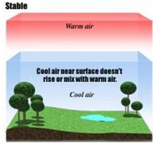
Figure 6:
This image depicts a typical stable, or stratified, environment where no
mixing occurs. |
The atmospheric motions that occur in
a stable environment are fundamentally different than those found in an unstable
environment. The most profound difference between these two types of
environments is the inhibition of vertical mixing in the stable environment.
The lack of vertical mixing leads to a "stratified" atmosphere, where many
atmospheric variables are separated into layers instead of being well-mixed.
The stratification of the atmosphere when stable leads to, for instance, pollution episodes
and drastic changes in wind speed and direction over short vertical distance. An example of a
stratified and stable environment can be seen in Figure 6 to the left.
Another atmospheric consequence of a
stable and stratified atmosphere involves the process of cloud formation.
Assuming that there is sufficient moisture present in the atmosphere, stratiform
clouds can form in a stable environment. This can only occur if the stable
air is forced upward either through the convergence of air into a low pressure
center or through the orographic lifting. An example of each of these
processes can be found below in Figure 7 and Figure 8.
|
 |
|
|
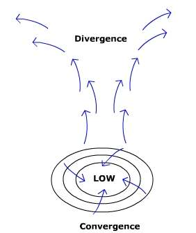
Figure 7:
This figure shows how air converges into the center of a low pressure system
and is forced to rise. |
Figure 8:
The demonstration above shows how air can be forced to rise due to a change
in topography. |
>>Temperature Inversions: The
"ultimate" in stability
As mentioned above, a temperature
inversion is the most stable environmental profile possible. This type of
atmospheric temperature profile can occur pretty much anywhere throughout the
atmosphere, aloft or near the ground- each having a different impact on the weather.
At the surface, temperature inversions
can form during both the daytime and the nighttime, depending on the conditions
and location. The more common type of inversion is the nocturnal
temperature inversion that occurs due to the radiational cooling of the Earth's
surface after the sun sets. A temperature inversion can also form
over cool bodies of water during the daytime in the summer.
Temperature inversions also occur
aloft in the stratosphere (the layer directly above the troposphere).
Inversions in this layer of the atmosphere limit the vertical
development of thunderstorms and their anvils (hence the name, stratosphere).
The last type of temperature inversion
is called a subsidence inversion. This type of temperature inversion is a
result of the sinking and warming of air parcels. In this case, however,
the top of the air parcel descends and warms more than the bottom of the air
parcel. This type of temperature inversion is generally found to the east
of high pressure systems well above the ground and well below the stratosphere.
Clouds
>> If formed in a stable environment,
they are flat in appearance (stratiform)
>> If formed in an unstable environment, they are puffy with good vertical
development (cumuliform)
>> The difference between water and ice clouds can be seen on the edges
Houze's Cloud Atlas
Cloudman's Mini Cloud Atlas
One can tell the difference between
clouds composed of primarily water and clouds composed of ice by looking at the
edges of the cloud. If the cloud has distinct, sharp edges, it is most
likely a water cloud. If the cloud is more diffuse, it is generally an ice cloud. The presense
of ice or water in a cloud says nothing, however, about the stability of the atmosphere near
the cloud. For stability clues, look at the vertical extent of the cloud.
In order to obtain a better understanding of the different cloud types, explore one or more of
the Cloud Atlases provided on this page.
|
|
|