|
Fronts
>> Boundary between two air masses
where relatively large temperature and/or moisture gradients can be found
>> Associated with relatively low surface pressure
|
 |
|
Figure 1:
Pictured above are the symbols for each type of front. |
Air around a frontal system converges
at the surface and is forced to rise. This rising air cools and eventually
condenses to form clouds and precipitation. The
basic structure of a front can be seen in Figure 4 of the
previous lecture.
The various symbols for each type of front can be seen to the right in Figure
1.
>> Warm Front: Cold air retreating
|
 |
|
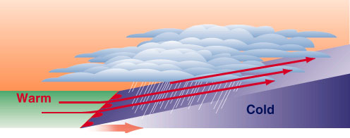
Figure 2:
The structure of a warm front is pictured above. Notice that the warm
air is forced to gradually rise above the cold air to form stratiform
clouds and steady precipitation. |
A front is considered to be a warm
front when the warm air overruns the cold air. This type of frontal system
is associated with the gradual ascent of the air, leading to stratiform clouds
and steady precipitation. The structure of a warm front can be seen in
Figure 2.
>> Cold Front: Cold air advancing
|
 |
|
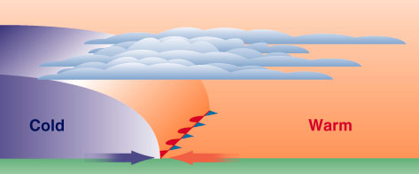
Figure 3:
The structure of a cold front is pictured above. Notice that the cold
air is advancing and forcing the warm air to rise rapidly in order to form
cumuliform clouds and more showery precipitation. |
A front is considered to be a cold
front when the cold air advances toward the warm air and undercuts it.
This type of frontal system is associated with the rapid ascent of the air,
leading to cumuliform clouds and convection. This convection leads to more
showery, but often heavy, precipitation such as thunderstorms. Figure 3,
to the right, depicts the typical structure of a cold front.
>> Occluded Front: Generally when warm
air at the surface is cut off from the surface low pressure center
|
 |
|
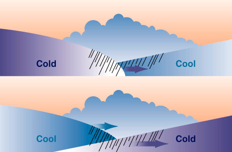
Figure 4:
The structure of the two types of occluded fronts can be seen above.
This type of front is often a sign of a mature and weakening low pressure
system. |
A front is considered to be an
occluded front once the warm air at the surface is cut off from the surface low
pressure system. This happens when "new" cold air begins to advance on the
"old" cold air. This type of front often has cold front characteristics
with showery precipitation. An occluded front is often a sign of a mature
and weakening low pressure system. The two types of occluded fronts can be
seen in Figure 4 to the left.
>> Stationary Front: Little or no
movement, cold air neither advancing nor retreating
|
 |
|
Figure 5:
The structure of a stationary front is depicted above. Notice that
neither the cold or warm air is advancing. Note that the blue arrow is in error and should be pointing
either into or out from the page to be technically correct (cold air should be moving parallel to the front). A front is defined by the direction
of movement of the cold, more dense air. |
A front is considered to be stationary
when there is little to no movement of the cold air. This type of front
can cause copious amounts of precipitation due to its very slow movement.
The structure of a stationary front can be seen in Figure 5 to the right.
>> Dryline/Dewpoint Front: Dry, warm
air displaces moist, warm air
A dryline, or dewpoint front, is
different than the fronts mentioned above. Instead of being concerned with
the movement of warm and cold air, this type of boundary is concerned with a
difference in moisture over a small horizontal distance.
In the dryline case, the dry air is
heavier than the moist air because the lighter water vapor
molecules replace some of the heavier oxygen and nitrogen molecules in moist
air. This causes the dryline to act like a cold front in the sense that
that dry air undercuts the moist air and causes the rapid lifting of the warm,
moist air. Like a cold front, these drylines produce convection and
showery, but often heavy, precipitation.
Cyclone Life Cycle
>> Birth
A cyclone usually develops along the
eastern side of an approaching upper-level trough. In response to the
approach of the trough, surface pressures fall, and since pressures are already low
in the vicinity of a surface front, a low pressure center forms along it.
>> Maturation
During the maturation stage of
cyclogenesis, the upper-level divergence increases. This, in turn, causes
the surface pressure to fall even further. As the surface pressure falls,
more air begins to converge into the center of the surface low. The
increase in convergence at the surface causes a circulation to develop in which
cold air in drawn Equatorward and warm air is drawn poleward.
>> Demise
The demise of a low pressure system
begins when the low pressure becomes cut off from the warm, moist air at the
surface. This causes the temperature gradient around the storm to
decrease. At upper-levels, divergence begins to decrease and more air
enters at the surface than exits aloft. This causes the surface pressure
to slowly rise and the cyclone to eventually die.
The life cycle of a mid-latitude
cyclone can be seen in Figure 6 below. You may need to reload the page to restart animation.
|
 |
|
Figure 6:
The animation above shows the typical life cycle of a mid-latitude cyclone
from birth to demise. |
|